


Real-Time Kinematic GPS
High-precision GPS solution providing accurate georeferencing for survey data in SENSYS magnetic and geophysical measurement systems.
Key Features:
✔️ Provides centimeter-level positioning accuracy for precise survey data
✔️ Compatible with GPS pod solutions with integrated online reference services
✔️ Supports classic base/rover setups with receivers and antennas
✔️ Unified NMEA input ensures seamless integration with all SENSYS systems
✔️ Adaptable to diverse field conditions for optimized positioning performance
✔️ Enhances geolocation of magnetic, UXO, and geophysical measurements
✔️ Supports real-time corrections for continuous accuracy during surveys
✔️ Consultative deployment matches GPS solution to system and client requirements
Real-Time Kinematic GPS
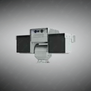
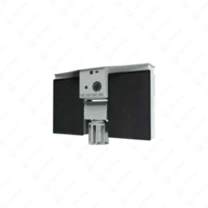
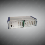
The Real-Time Kinematic GPS solutions include pod configurations with integrated online reference services and traditional base-rover setups featuring separate receiver and antenna components. All systems output NMEA string format data ensuring compatibility across survey equipment platforms through unified input protocols. Pod solutions connect to internet-based correction services eliminating the need for physical base station deployment at survey sites. Base-rover configurations establish local reference stations transmitting differential corrections to mobile rover units during field operations.
Receiver units process satellite signals from multiple GNSS constellations including GPS, GLONASS, Galileo, and BeiDou for improved position availability in challenging sky visibility conditions. Antenna specifications vary based on survey system requirements and site-specific interference conditions. The systems achieve centimeter-level horizontal accuracy and decimeter-level vertical precision during real-time position determination. Configuration selection depends on factors including site remoteness, cellular network availability, survey duration, and required positional accuracy specifications.
Geophysical survey contractors integrate Real-Time Kinematic GPS with magnetometer arrays for precise anomaly coordinate assignment during mineral exploration grid surveys. Archaeological mapping teams use it to georeferenced artifact detection locations within established site coordinate systems. Utility location services employ the technology for accurate as-built documentation of buried infrastructure position during subsurface detection projects. Environmental consulting firms utilize it to establish sample point coordinates during contaminated site characterization investigations requiring spatial data integration with laboratory analytical results.
Tactical Supply Pakistan provides precision positioning solutions for survey professionals requiring accurate geospatial referencing of field measurement data across diverse operational environments and equipment configurations.
What advantage does online correction service provide compared to base-rover configurations?
Online services eliminate base station setup time and equipment transport requirements at remote survey locations. Networked reference stations maintained by service providers offer wider geographic coverage than single base stations, improving correction accuracy across larger survey areas.
- Fast Shipping: We partner with reliable delivery services to make sure your order gets to you quickly. We work hard to ensure every package arrives safely and on time.
- Quick Processing: Your order is processed and prepared for shipping within 24 to 48 hours. This allows us to send it out to you as fast as possible after your payment is confirmed.
- Tracking: Once your order is on its way, we will provide you with a tracking number. You can use this number to easily follow your package's journey and know exactly when it will arrive.
- Nationwide Delivery: We offer delivery to all locations across Pakistan, including major cities and remote areas. No matter where you are, we can get your order to you.
At Tactical Supply Pakistan, our relationship with you doesn't end after a sale. We are dedicated to making the long-term performance and reliability of our high-quality tactical and supplied equipment. Our commitment is to provide you with seamless support and peace of mind.
- Free Installation: We'll set up your new equipment for you, so it's ready to go. You can focus on your work while our engineers handle as per the guidelines for manufacturer.
- Maintenance: We offer quick replacements where necessary, to keep your gear in top condition. Our team will make sure your equipment is always ready when you need it.
- Customer Support: We're always here to help. Our support team is available to answer your questions and assist you long after you've made a purchase.
- Planned Preventative Maintenance: Our service includes preventative maintenance to keep your equipment in peak condition and prevent future issues.
HAVE QUESTIONS?
Fill out the form, and our team will respond promptly to assist with your product inquiries or order support.