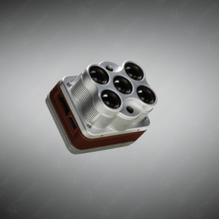
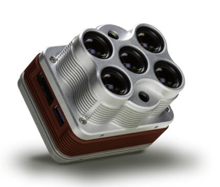
MicaSense Altum-PT Multispectral Camera
The MicaSense Altum-PT is a combined multispectral and thermal imaging camera system built for UAV-based precision agriculture, vegetation health mapping, and environmental monitoring missions. It integrates five discrete multispectral bands, a panchromatic band for image sharpening, and a FLIR Lepton thermal sensor into a single compact payload — delivering synchronized radiometrically calibrated imagery across optical and thermal wavelengths from a single flight.
The five multispectral bands cover blue at 475nm, green at 560nm, red at 668nm, red edge at 717nm, and near-infrared at 842nm — each with 3.2MP resolution. The co-boresighted panchromatic band captures 18MP monochrome imagery at the same instant as the multispectral channels, enabling pan-sharpening of multispectral outputs to higher spatial resolution for detailed crop row and individual plant analysis. Furthermore, the integrated FLIR Lepton 3.5 thermal sensor delivers 160×120 pixel radiometric thermal imagery at a sensitivity of 50 millikelvin — detecting crop water stress, soil moisture variation, and equipment heat signature without a separate thermal payload on the UAV.
All bands capture simultaneously using a single global shutter trigger — eliminating band misregistration errors caused by sequential capture at different positions during UAV flight. A downwelling light sensor (DLS 2) mounts on top of the UAV and measures ambient light conditions at the moment of each capture — enabling accurate radiometric calibration of reflectance values without requiring a reflectance panel on every flight. Additionally, GPS position and IMU attitude data embed in each image’s metadata — supporting direct georeferencing without ground control points on mapped areas where GCP placement is impractical.
The Altum-PT weighs 400 grams and measures 82.9×68.3×68.3mm — compatible with DJI M300 RTK, Autel EVO II Pro, and other professional mapping UAV platforms. Output indices including NDVI, NDRE, GNDVI, and thermal temperature maps process directly in Pix4Dfields, Agisoft Metashape, and DroneDeploy software.
These systems serve Pakistan’s agricultural research programs in Punjab’s cotton and wheat zones, irrigation management authorities monitoring crop water stress in Sindh, sugarcane plantation operators in KPK, and university agriculture and remote sensing departments in Lahore and Faisalabad requiring high-resolution multispectral and thermal UAV data for precision agriculture decision-making.
Tactical Supply Pakistan supplies the MicaSense Altum-PT for precision agriculture mapping, crop health monitoring, and UAV multispectral survey procurement across Pakistan.
Showing the single result