


A heavy-duty vehicle-mounted magnetometer system engineered for rapid, high-resolution mapping of ferromagnetic objects across large and challenging terrains.
Key Features:
✔️ Vehicle-based magnetometer system for wide-area ground surveys
✔️ Designed for explosive ordnance detection and contaminated land investigation
✔️ All-terrain carrier optimized for difficult soils and remote locations
✔️ Configurable measurement setup for varied survey requirements
✔️ Supports wide survey coverage with multi-sensor deployment
✔️ High-resolution detection of buried ferromagnetic objects and structures
✔️ Suitable for long-duration, continuous field operations
✔️ Applied across EOD, geophysics, archaeology, and site assessment missions
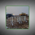
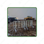
The vehicle-based ferromagnetic objects Magnetometer system extends to 4 meters in width and accommodates between 8 and 16 fluxgate magnetometer probes mounted on an all-terrain heavy-duty carrier. The vehicle-towed platform operates at survey speeds covering up to 25 hectares daily depending on terrain conditions. Each magnetometer uses 24-bit digitization with high sampling rates for accurate data capture. The system integrates RTK differential GPS positioning with accuracy within 1 centimeter for every measurement point. The non-magnetic carrier construction prevents interference with sensor readings during field operations.
The modular configuration adjusts from 2 meters to maximum 4-meter width based on survey requirements and vehicle specifications. Data acquisition runs through the MonMX software on rugged tablets with Windows operating systems. The equipment supports Ethernet interface connectivity for integration with third-party navigation and recording systems. The carrier features reinforced suspension components for operation across uneven ground surfaces and rough vegetation.
Military explosive ordnance disposal teams deploy the vehicle-based ferromagnetic objects Magnetometer across former battlefields contaminated with unexploded bombs and artillery shells buried at depths exceeding 3 meters. Engineering battalions utilize the system for pre-construction surveys before establishing forward operating bases in conflict zones. Geophysical research units operate the equipment for subsurface mapping of geological formations in remote mineral exploration sites. Archaeological institutions employ the platform for large-scale investigation of historical fortification systems and ancient settlement patterns.
Tactical Supply Pakistan supplies robust survey equipment engineered to withstand extreme operational demands in challenging field environments.
How does the heavy-duty carrier maintain sensor spacing accuracy during high-speed surveys over rough terrain?
The rigid frame construction eliminates flex-induced positional errors common in lightweight systems, while reinforced mounting brackets secure each magnetometer at fixed intervals. Real-time kinematic GPS corrections compensate for vehicle roll and pitch variations across slopes.
At Tactical Supply Pakistan, our relationship with you doesn't end after a sale. We are dedicated to making the long-term performance and reliability of our high-quality tactical and supplied equipment. Our commitment is to provide you with seamless support and peace of mind.
Fill out the form, and our team will respond promptly to assist with your product inquiries or order support.
WhatsApp us