


An advanced subsurface detection system using ultra-wideband radar to accurately locate and map metallic and non-metallic underground utilities with high clarity.
Key Features:
✔️ Detects metallic and non-metallic buried utilities
✔️ Ultra-wideband radar for high-resolution subsurface imaging
✔️ Effective for pipes, cables, ducts, and voids
✔️ Reliable depth detection in complex ground conditions
✔️ Integrated GPS for geo-referenced utility mapping
✔️ High-resolution touch display for on-site interpretation
✔️ One-touch data capture with image annotation support
✔️ Rugged, weather-resistant design for field operations
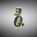
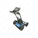
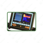
The Utility Ground Penetrating Radar systems utilize ultra-wideband radar frequencies to image subsurface infrastructure including plastic pipes and ceramic conduits at depths reaching 8 meters. The RD1100 base model combines a ruggedized antenna assembly with integrated GPS receivers that automatically timestamp and geotag detection data during field surveys. Its touchscreen display measures diagonally across a high-resolution panel enabling real-time subsurface visualization without secondary processing equipment.
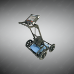
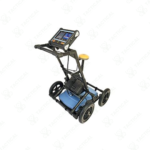
The RD1500 advanced variant adds Depth Slice processing that segments radar returns into horizontal planes for layer-by-layer analysis. FrequenSee technology permits operators to optimize radar response for shallow targets under 2 meters or deeper objects beyond 5 meters by adjusting effective frequency ranges. Internal Wi-Fi modules transmit survey data wirelessly to tablets and laptops for immediate reporting. USB ports support direct connection to external storage devices. Weatherproof housings protect electronic components during rain and dusty conditions. Lightweight construction allows single-operator deployment across extended survey areas.
Construction planners use Utility Ground Penetrating Radar before excavation projects to map PVC water distribution networks and fiberglass telecommunication ducts invisible to electromagnetic detection methods. Military engineering battalions scan proposed building sites to identify abandoned concrete utility tunnels and non-metallic drainage systems. Naval base infrastructure teams employ GPR imaging when expanding pier facilities where historical plans omit details of subsurface storm water pipes. Airforce personnel survey around hardened aircraft shelters detecting buried fuel lines and communication conduits before maintenance activities commence.
Tactical Supply Pakistan supplies these radar location systems to surveying professionals requiring detection of both conductive and non-conductive buried assets where conventional locating technology proves insufficient.
How does Depth Slice improve subsurface mapping accuracy?
Depth Slice divides continuous radar data into discrete horizontal layers at user-defined depths, revealing the plan-view position of utilities at each level separately rather than displaying all depths simultaneously on traditional profile views.
At Tactical Supply Pakistan, our relationship with you doesn't end after a sale. We are dedicated to making the long-term performance and reliability of our high-quality tactical and supplied equipment. Our commitment is to provide you with seamless support and peace of mind.
Fill out the form, and our team will respond promptly to assist with your product inquiries or order support.
WhatsApp us


