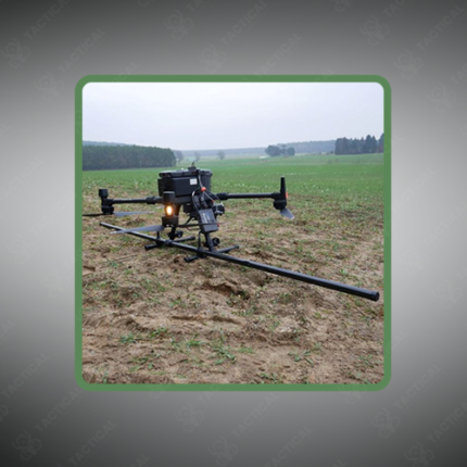
Drone Magnetometers for Aerial Magnetic Surveys
Drone Magnetometers for Aerial Magnetic Surveys are purpose-built sensing systems combining a UAV platform with a calibrated magnetic field sensor, data acquisition electronics, and georeferencing hardware to collect spatially referenced magnetic measurements across defined survey areas. The integrated system replaces conventional ground-based magnetometer traverses and manned aircraft surveys with a cost-effective, rapidly deployable alternative that maintains data quality while reducing operational risk and mobilization time.
The magnetometer sensor — fluxgate, cesium vapor, potassium vapor, or optically pumped (OPM) depending on the required sensitivity — is mounted on a carbon fiber boom extending 0.5 to 2 meters below or ahead of the UAV airframe, physically separating the sensor from the platform’s magnetic noise sources including brushless motors, lithium polymer battery packs, and electronic speed controllers. Sensor sensitivity ranges from 0.1 nT for fluxgate units to below 0.001 nT per root hertz for vapor magnetometers, with sampling rates between 100Hz and 1,000Hz synchronized to GPS position logging.
Flight parameters for aerial magnetic surveys are defined by the target anomaly resolution. Line spacing between 5 and 100 meters is selected based on expected anomaly depth and lateral extent, with flight altitude maintained between 10 and 120 meters above ground level using barometric and terrain-following controls. UAV flight endurance ranges from 30 minutes on multirotor platforms to over 90 minutes on fixed-wing survey drones, covering areas from a few hectares to several square kilometers per sortie.
Raw data processing applies heading corrections, diurnal variation removal, and magnetic interference compensation before gridding into total magnetic intensity (TMI) or reduced-to-pole (RTP) maps for anomaly interpretation.
In Pakistan, aerial magnetic survey systems using drone magnetometers are applied across mineral exploration programs in Balochistan and KPK, UXO clearance operations in former conflict zones, buried pipeline and utility mapping, and geological structural surveys.
Tactical Supply Pakistan supplies drone magnetometers and complete aerial magnetic survey systems for geological, defense, and infrastructure survey procurement nationwide.
Showing the single result