


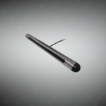

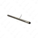
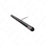
Side-Scan Transducers
High-resolution ultrasonic transducers for precise seafloor imaging and underwater mapping in commercial and scientific applications.
Key Features
✔️ High-resolution ultrasonic imaging for detailed seafloor and sub-surface mapping
✔️ Rugged, durable construction for marine and field deployment
✔️ Multiple frequency options 200 kHz, 340 kHz, 500 kHz for varied survey environments
✔️ Configurable beam patterns for optimized coverage and imaging resolution
✔️ Portable and easy to integrate with existing survey and mapping systems
✔️ Ideal for large-area surveys, shallow water mapping, and coastal research
✔️ Maintenance-free ultrasonic design reduces operational downtime
✔️ Compatible with standard hydrographic and oceanographic data systems
Side-Scan Transducers
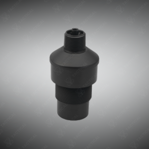
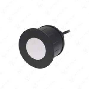
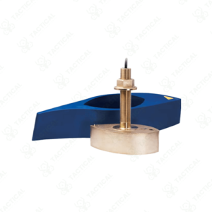
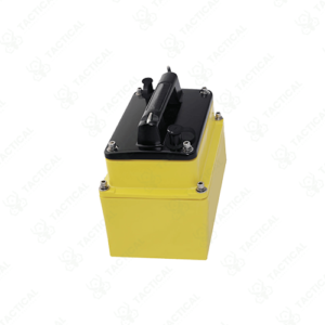
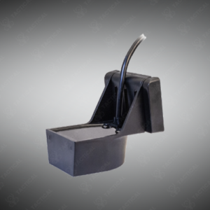
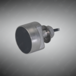
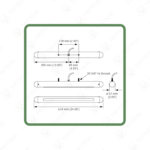
The Side-Scan Transducers generate high-resolution acoustic imagery of seafloor topography and underwater objects through horizontally-oriented ultrasonic beams. These sensors transmit sound pulses perpendicular to the direction of travel, capturing return echoes that construct detailed images of bottom features and submerged structures. Model SS82 operates at approximately 200 kHz with configurable beam patterns for large-area coverage in moderate depth environments. The SS134 variant functions at dual frequencies of 340 kHz and 500 kHz, optimizing resolution for shallow coastal surveys and detailed inspection work.
Ruggedized construction withstands harsh marine conditions during extended deployment periods. Beam geometry adjusts to balance swath width against image resolution based on survey objectives and water depth. Ultrasonic design eliminates moving parts, reducing mechanical failures common in rotating scanning systems. Portable configurations enable rapid deployment from small survey vessels or temporary mounting on remote sensing platforms. Integration compatibility with standard hydrographic survey software allows direct data streaming into mapping applications
Naval mine countermeasure units deploy Side-Scan Transducers for underwater ordnance detection and classification during clearance operations. Marine archaeology teams use these sensors to locate shipwrecks and submerged cultural heritage sites across extensive search areas. Coast guard search and rescue divisions employ side-scan sonar for locating submerged aircraft wreckage and missing vessels. Military engineering battalions conduct pre-construction surveys of underwater bridge pier locations and pipeline routes using side-scan imaging.
Tactical Supply Pakistan offers side-scan transducer systems for organizations requiring detailed underwater imaging capabilities in hydrographic and search operations.
What swath width can side-scan transducers typically image per survey pass?
Swath width varies with frequency and altitude above bottom, ranging from 50 to 300 meters total coverage per pass depending on configuration and operating depth.
- Fast Shipping: We partner with reliable delivery services to make sure your order gets to you quickly. We work hard to ensure every package arrives safely and on time.
- Quick Processing: Your order is processed and prepared for shipping within 24 to 48 hours. This allows us to send it out to you as fast as possible after your payment is confirmed.
- Tracking: Once your order is on its way, we will provide you with a tracking number. You can use this number to easily follow your package's journey and know exactly when it will arrive.
- Nationwide Delivery: We offer delivery to all locations across Pakistan, including major cities and remote areas. No matter where you are, we can get your order to you.
At Tactical Supply Pakistan, our relationship with you doesn't end after a sale. We are dedicated to making the long-term performance and reliability of our high-quality tactical and supplied equipment. Our commitment is to provide you with seamless support and peace of mind.
- Free Installation: We'll set up your new equipment for you, so it's ready to go. You can focus on your work while our engineers handle as per the guidelines for manufacturer.
- Maintenance: We offer quick replacements where necessary, to keep your gear in top condition. Our team will make sure your equipment is always ready when you need it.
- Customer Support: We're always here to help. Our support team is available to answer your questions and assist you long after you've made a purchase.
- Planned Preventative Maintenance: Our service includes preventative maintenance to keep your equipment in peak condition and prevent future issues.
HAVE QUESTIONS?
Fill out the form, and our team will respond promptly to assist with your product inquiries or order support.