


Time Domain Electromagnetics Survey System
A versatile TDEM survey system for high-resolution detection and mapping of ferrous and non-ferrous subsurface objects in geophysical, archaeological, and environmental applications.
Key Features:
✔️ High-resolution TDEM technology for precise subsurface object detection
✔️ Supports small-area portable (SMD12) and large-area cart-based (EMD2) surveys
✔️ Integrated digital data logging with optional DGPS for georeferenced mapping
✔️ Rapid deployment and intuitive operation for field surveys
✔️ Differential coil configurations enhance target separation and accuracy
✔️ Rugged design suitable for diverse terrains and environmental conditions
✔️ Lightweight and portable options for hard-to-access sites
✔️ Flexible configurations to match survey scale, resolution, and operational needs
Time Domain Electromagnetics Survey System
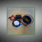
The Time Domain Electromagnetics Survey System transmits electromagnetic pulses into the ground and records decay responses from subsurface metallic objects using differential receiver coil configurations. This TDEM technology detects both ferrous and non-ferrous materials through time-domain signal analysis. The system integrates digital data logging with optional DGPS receivers that tag measurements with precise geographic coordinates during field operations.
Two primary models address different survey scales and mobility requirements. The EMD2 TDEM Multi-Sensor mounts three differential receiver coil pairs on a cart platform for medium to large area coverage with high spatial resolution. The SMD12 portable unit features a foldable coil frame weighing approximately 3.2 kilograms that assembles in under two minutes for rapid deployment. Both configurations support standalone operation or connectivity with PDA devices and Bluetooth-enabled computers for real-time data visualization.
Military ranges deploy the Time Domain Electromagnetics Survey System to locate buried unexploded ordnance and spent munitions across training facilities before civilian land transfer. Environmental consultants map contaminated industrial sites to identify buried metal drums and underground storage tanks leaking hazardous substances. Archaeological teams use portable TDEM units to discover metal artifacts and structural foundations without excavation damage to historical sites. Mining companies conduct geophysical surveys with cart-based systems to delineate conductive ore bodies and map subsurface geological structures across exploration claims.
Tactical Supply Pakistan supplies both EMD2 cart-based and SMD12 portable TDEM systems with complete data logging accessories and DGPS integration hardware for georeferenced surveys. The distributor stocks replacement coil assemblies and field-proven survey mapping software packages.
How does TDEM differentiate between ferrous and non-ferrous buried objects during field surveys?
TDEM analyzes electromagnetic decay curves that vary based on object conductivity and magnetic permeability. Ferrous materials produce longer decay times due to magnetic properties, while non-ferrous metals generate characteristic decay signatures based solely on conductivity values.
- Fast Shipping: We partner with reliable delivery services to make sure your order gets to you quickly. We work hard to ensure every package arrives safely and on time.
- Quick Processing: Your order is processed and prepared for shipping within 24 to 48 hours. This allows us to send it out to you as fast as possible after your payment is confirmed.
- Tracking: Once your order is on its way, we will provide you with a tracking number. You can use this number to easily follow your package's journey and know exactly when it will arrive.
- Nationwide Delivery: We offer delivery to all locations across Pakistan, including major cities and remote areas. No matter where you are, we can get your order to you.
At Tactical Supply Pakistan, our relationship with you doesn't end after a sale. We are dedicated to making the long-term performance and reliability of our high-quality tactical and supplied equipment. Our commitment is to provide you with seamless support and peace of mind.
- Free Installation: We'll set up your new equipment for you, so it's ready to go. You can focus on your work while our engineers handle as per the guidelines for manufacturer.
- Maintenance: We offer quick replacements where necessary, to keep your gear in top condition. Our team will make sure your equipment is always ready when you need it.
- Customer Support: We're always here to help. Our support team is available to answer your questions and assist you long after you've made a purchase.
- Planned Preventative Maintenance: Our service includes preventative maintenance to keep your equipment in peak condition and prevent future issues.
HAVE QUESTIONS?
Fill out the form, and our team will respond promptly to assist with your product inquiries or order support.


