


Fiber Optic Inertial Navigation System
Compact and high-performance fiber optic navigation systems providing accurate, reliable positioning, heading, and attitude data even in GNSS-denied or high-interference environments.
Key Features:
✔️ Fiber optic inertial navigation with self-north-seeking for rapid alignment
✔️ Multi-mode navigation: pure inertial, GNSS-assisted, DVL, and odometer integration
✔️ High-accuracy heading, attitude, and position measurements across all models
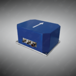
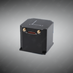
✔️ Compact, lightweight aluminum housing for drones, marine, and unmanned platforms
✔️ Multiple communication interfaces: RS232, RS422, CAN, Ethernet for integration
✔️ Continuous, reliable navigation under GNSS denial or electromagnetic interference
✔️ Low power consumption with high operational reliability for extended missions
✔️ Meets military standards GJB150.16A-2009 and GJB150.18A-2009 for shock/vibration
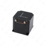
Fiber Optic Inertial Navigation System
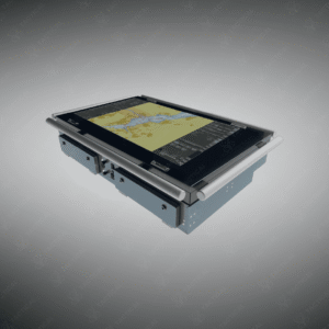
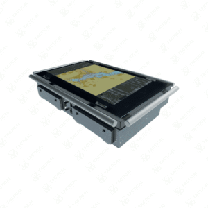
The Fiber Optic Inertial Navigation System delivers positioning and attitude data through solid-state gyroscopes and accelerometers without reliance on external signals. The INS170 model weighs 600 grams in an 80×80×74 mm housing, consuming 8 watts at DC 12-36V input. It achieves 0.8°×secφ north-seeking accuracy and maintains 1 km position drift over 10 minutes in pure inertial mode. The INS570 expands to 850 grams with 12-watt consumption, providing centimeter-level positioning when fused with satellite, odometer, or Doppler velocity log inputs.
The INS970 scales to 3 kg at 160×132×117 mm dimensions, drawing 15 watts while achieving 0.05°×secφ north-seeking precision and 0.05° heading accuracy. The INS1700 tops the range at 7 kg in a 179.6×179.6×145 mm aluminum housing, consuming 20 watts to deliver 0.003° attitude accuracy and 0.5 nautical mile per hour drift in GNSS-denied environments. All models integrate RS232, RS422, CAN, and Ethernet interfaces for sensor fusion with external navigation aids. Kalman filtering algorithms compensate for gyroscope drift through continuous error state estimation.
Military reconnaissance drones deploy the Fiber Optic Inertial Navigation System to maintain flight paths during GPS jamming operations in contested airspace. Autonomous underwater vehicles use INS970 units fused with DVL sensors to navigate subsurface mapping missions without satellite access. Armored personnel carriers mount these systems to track position through tunnels and urban canyons where buildings block GNSS signals. Survey teams employ INS1700 models for geodetic control measurements in remote valleys where satellite geometry degrades accuracy.
Tactical Supply Pakistan stocks the complete Inertial Navigation System series for defense contractors and research institutions requiring GNSS-independent positioning capability. Our engineers support integration planning for platforms with constrained power budgets and volume allocations requiring compact navigation solutions.
Can the INS570 continue navigation if satellite signals drop during operation?
Yes. The system switches to pure inertial mode automatically, maintaining navigation through satellite outages using internal gyroscopes and accelerometers.
- Fast Shipping: We partner with reliable delivery services to make sure your order gets to you quickly. We work hard to ensure every package arrives safely and on time.
- Quick Processing: Your order is processed and prepared for shipping within 24 to 48 hours. This allows us to send it out to you as fast as possible after your payment is confirmed.
- Tracking: Once your order is on its way, we will provide you with a tracking number. You can use this number to easily follow your package's journey and know exactly when it will arrive.
- Nationwide Delivery: We offer delivery to all locations across Pakistan, including major cities and remote areas. No matter where you are, we can get your order to you.
At Tactical Supply Pakistan, our relationship with you doesn't end after a sale. We are dedicated to making the long-term performance and reliability of our high-quality tactical and supplied equipment. Our commitment is to provide you with seamless support and peace of mind.
- Free Installation: We'll set up your new equipment for you, so it's ready to go. You can focus on your work while our engineers handle as per the guidelines for manufacturer.
- Maintenance: We offer quick replacements where necessary, to keep your gear in top condition. Our team will make sure your equipment is always ready when you need it.
- Customer Support: We're always here to help. Our support team is available to answer your questions and assist you long after you've made a purchase.
- Planned Preventative Maintenance: Our service includes preventative maintenance to keep your equipment in peak condition and prevent future issues.
HAVE QUESTIONS?
Fill out the form, and our team will respond promptly to assist with your product inquiries or order support.