


A modular, high-performance magnetometer system designed for flexible, large-area surveys in UXO clearance, archaeology, and geophysical exploration.
Key Features:
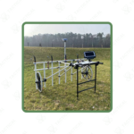
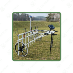
✔️ Large-area magnetometer system supporting up to 16 sensors
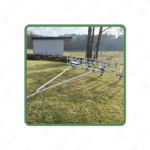
✔️ Modular carrier with adjustable probe width from 1 to 4 meters
✔️ Carrier width up to 3.85 m for efficient wide-swath surveying
✔️ Flexible deployment for push or vehicle-mounted operation
✔️ High-speed data acquisition with 200 Hz sampling and 24-bit digitization
✔️ Operable with 5 to 16 probes for scalable survey configurations
✔️ Precise spatial data supported through RTK DGPS integration
✔️ Optional wireless data transmission and specialized transport solutions
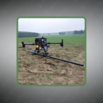
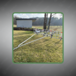
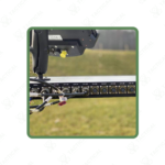
The expand flexibly magnetometer system accommodates 5 to 16 FGM650 fluxgate gradiometers mounted on a metal-free modular carrier spanning 3.85 meters maximum width. The digitization unit processes signals at 200 Hz sampling frequency with 24-bit analog-to-digital conversion across all channels simultaneously. The system records spatial data points every 20 mm at survey speeds reaching 15 km/h. The non-magnetic cart construction prevents magnetic interference during measurements. The carrier adjusts from 1 meter push-cart configuration to 4 meter vehicle-towed arrangement without hardware modifications.
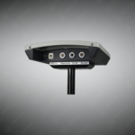
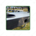
The data acquisition box connects via Ethernet LAN interface delivering 100 Mbits per second throughput to field computers. RTK differential GPS receivers achieve ±1 cm positioning accuracy through local base stations or online correction services. The 12-volt lead gel battery pack powers continuous 8-hour field operations. Optional waterproof cable assemblies enable shallow water surveys for submerged ordnance detection. The modular design permits system expansion through software licensing upgrades rather than equipment replacement. Transport cases and vehicle trailer solutions facilitate mobilization to remote survey locations.
Military explosive ordnance disposal teams deploy the expand flexibly magnetometer system for clearance verification across former artillery impact ranges before land reuse initiatives. Engineering battalions utilize the equipment for pre-construction surveys identifying buried ammunition at proposed base expansion sites. Naval construction units operate the platform for harbor dredging operations requiring underwater ordnance mapping. Air force civil engineering squadrons employ the technology for runway safety assessments detecting subsurface metallic debris. Archaeological institutions conduct large-scale geophysical prospection mapping ancient fortifications and settlement patterns.
Tactical Supply Pakistan provides scalable detection platforms that adapt to diverse operational requirements while maintaining exceptional measurement accuracy.
How does the license-based expansion model reduce operational costs compared to purchasing additional complete systems?
Organizations purchase base hardware once, then unlock additional sensor channels through software keys as project requirements grow. This eliminates redundant digitization units and GPS receivers while maintaining full compatibility with existing field procedures and data processing workflows.
At Tactical Supply Pakistan, our relationship with you doesn't end after a sale. We are dedicated to making the long-term performance and reliability of our high-quality tactical and supplied equipment. Our commitment is to provide you with seamless support and peace of mind.
Fill out the form, and our team will respond promptly to assist with your product inquiries or order support.
WhatsApp us


