


A stationary field magnetometer system designed for precise, long-duration measurements and integration with mobile SENSYS systems for geophysical, UXO, and environmental surveys.
Key Features:
✔️ Single FGM3D/75 fluxgate sensor for high-precision three-axis measurement
✔️ Self-contained data logger with at least 24 hours continuous recording
✔️ Integrated GPS timestamps for accurate georeferencing
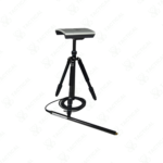
✔️ Tripod-mounted sensor with accelerometer to detect orientation and tipping
✔️ Compatible with MagDrone R3, MAGNETO BM2, and other SENSYS setups
✔️ 12 V lead-gel battery powers field operations with 500 mA consumption
✔️ Data export via MagDrone DataTool and MAGNETO® software for GIS/MATLAB
✔️ Rugged package includes tripod, sensor, battery, and protective case
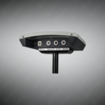
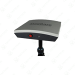
The MagBase Magnetometer-based Stationary Field Instrument features an FGM3D/75 fluxgate magnetometer mounted on a stable tripod for fixed-position measurements. The sensor operates across ±75,000 nanotesla specified range with three-axis data capture at 200Hz sampling rate. Internal data logger contains 2GB memory storing minimum 24 hours continuous measurement data from all sensor axes. The system draws 500 milliamperes total power consumption from a 12-volt 7-ampere-hour lead-gel battery. Integrated U-Blox PAM-7Q GPS module timestamps all measurements for correlation with mobile survey data.
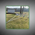
Built-in accelerometer monitors station orientation and triggers error alerts if the tripod tips during recording sessions. The data logger measures 220 x 220 x 50/70 millimeters and features on/off plus start/stop button controls with status LED indicators. Operating temperature range spans -20°C to +50°C for year-round deployment capability. The complete system ships in a 660 x 500 x 330 millimeter rugged transport case containing the logger, sensor, tripod, battery, charger, USB cables, international power adapters, and MagDrone DataTool software.
Geophysical survey teams position the MagBase Magnetometer-based Stationary Field Instrument as reference stations during mobile magnetometer surveys to subtract temporal magnetic variations from field readings. Archaeological excavation sites use it to monitor vehicle traffic interference during precision subsurface mapping operations. Research institutions deploy multiple units across study areas recording synchronized magnetic storm activity for ionospheric disturbance analysis. Mining exploration companies install them near drill sites capturing baseline magnetic signatures before heavy equipment operations commence.
Tactical Supply Pakistan delivers professional stationary monitoring solutions for scientists and surveyors requiring synchronized reference measurements during complex multi-sensor magnetic field mapping campaigns.
How does GPS timestamping enable correlation between stationary and mobile magnetometer data?
GPS provides microsecond-accurate universal time stamps for all measurements regardless of equipment location. Mobile survey data and stationary reference readings captured at identical timestamps can be mathematically subtracted to remove temporal variations like solar magnetic storms.
At Tactical Supply Pakistan, our relationship with you doesn't end after a sale. We are dedicated to making the long-term performance and reliability of our high-quality tactical and supplied equipment. Our commitment is to provide you with seamless support and peace of mind.
Fill out the form, and our team will respond promptly to assist with your product inquiries or order support.
WhatsApp us


