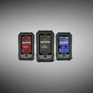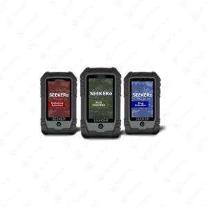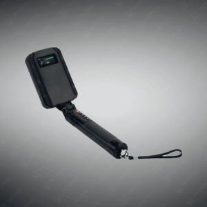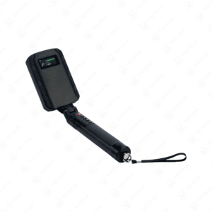


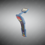
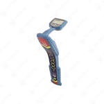
Underground Utility Locator
Advanced underground utility locator delivering accurate, reliable, and repeatable detection of pipes, cables, and RF markers, even in complex and congested networks.
Key Features:
✔️ Locates metallic and non-metallic utilities with high precision
✔️ Detects RF markers with automatic depth estimation (M series)
✔️ Bluetooth® connectivity for seamless data transfer and integration
✔️ Digital interface for easy operation and quick interpretation
✔️ Maintains accuracy across varied soil types and congested utility networks
✔️ Reliable performance in large-scale and complex underground environments
✔️ Repeatable results for consistent utility locating and mapping
✔️ Rugged, field-ready design suitable for professional surveying and construction
Underground Utility Locator
Underground Utility Locator detects electromagnetic signals emitted by buried cables and pipes, enabling operators to trace their routes and measure depth before excavation. The RD7000+ range operates across multiple frequency bands from passive power detection through active transmitter frequencies, with digital signal processing that filters ground distortion caused by soil conductivity variations and adjacent conductor interference. The receiver features providing directional guidance through visual bar graphs and proportional audio tones that peak when centered over target utilities.
Models designated with ‘M’ suffix incorporate RF marker detection capability alongside standard electromagnetic tracing functions. These variants automatically estimate marker depth when passive resonant tags are detected, displaying burial measurements without requiring signal transmission. Bluetooth connectivity enables wireless pairing with compatible transmitters for remote frequency selection and power adjustment during active tracing operations. The units feature impact-resistant housings with sealed membrane keypads rated for moisture and dust ingress protection.
Municipal utility crews deploy the Underground Utility Locator to mark cable and pipe positions before road repair and sidewalk replacement projects commence. Military base engineers trace communication lines and power distribution cables across training facilities during infrastructure upgrade planning. Navy public works departments locate underground utilities serving pier buildings and warehouse complexes before foundation work or utility connection modifications. Airforce civil engineering flights map buried electrical conduits and communication lines before hangar expansion and runway lighting system installations.
Tactical Supply Pakistan provides digital utility locators delivering repeatable detection performance across diverse soil conditions and congested underground networks. The company supports excavation safety programs requiring verified subsurface utility marking.
How does digital signal processing improve location accuracy in distorted ground conditions?
Digital filtering algorithms isolate target signals from electromagnetic noise and adjacent conductor interference, maintaining accurate depth readings and trace guidance where analog locators produce unstable measurements.
- Fast Shipping: We partner with reliable delivery services to make sure your order gets to you quickly. We work hard to ensure every package arrives safely and on time.
- Quick Processing: Your order is processed and prepared for shipping within 24 to 48 hours. This allows us to send it out to you as fast as possible after your payment is confirmed.
- Tracking: Once your order is on its way, we will provide you with a tracking number. You can use this number to easily follow your package's journey and know exactly when it will arrive.
- Nationwide Delivery: We offer delivery to all locations across Pakistan, including major cities and remote areas. No matter where you are, we can get your order to you.
At Tactical Supply Pakistan, our relationship with you doesn't end after a sale. We are dedicated to making the long-term performance and reliability of our high-quality tactical and supplied equipment. Our commitment is to provide you with seamless support and peace of mind.
- Free Installation: We'll set up your new equipment for you, so it's ready to go. You can focus on your work while our engineers handle as per the guidelines for manufacturer.
- Maintenance: We offer quick replacements where necessary, to keep your gear in top condition. Our team will make sure your equipment is always ready when you need it.
- Customer Support: We're always here to help. Our support team is available to answer your questions and assist you long after you've made a purchase.
- Planned Preventative Maintenance: Our service includes preventative maintenance to keep your equipment in peak condition and prevent future issues.
HAVE QUESTIONS?
Fill out the form, and our team will respond promptly to assist with your product inquiries or order support.