


Intelligent Airborne Electronic Reconnaissance System
Intelligent Airborne Electronic Reconnaissance System is a UAV-based platform for high-precision electronic reconnaissance and tactical spectrum monitoring.
Key Features:
✔️ Total takeoff weight: 16.8 kg, compact foldable airframe
✔️ Flight time: >32 minutes with video transmission range >8 km
✔️ Wide-angle camera gimbal with 84° diagonal field of view
✔️ Integrated STA200 radio module covering 0.4–6 GHz frequencies
✔️ Detection range: up to 10 km for FPV controller signals
✔️ Direction-finding accuracy: 1.5° RMS, tracking 6+ simultaneous targets
✔️ Radio module refresh rate: updates target data every 2 seconds
✔️ Operational temperature: -20°C to +50°C with <20W module consumption
✔️ Airborne 3D localization for UAVs, communication nodes, and radar emitters
✔️ Ideal for military, border security, and critical infrastructure protection
Intelligent Airborne Electronic Reconnaissance System
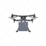
The Skyfend Tracer Air II is an Intelligent Airborne Electronic Reconnaissance System with a total takeoff weight of 16.8 kilograms. Its airframe measures 1510mm by 1472.5mm by 687.6mm when unfolded. The integrated STA200 radio detection module operates across the 0.4 to 6 GHz frequency band. This module weighs 3600 grams and has dimensions of 360mm by 360mm by 75mm. The system includes a wide-angle camera gimbal with an 84-degree diagonal field of view and a fixed-focus lens. The unmanned aerial vehicle offers a maximum flight time exceeding 32 minutes and a video transmission range greater than 8 kilometers.
This platform provides a detection range up to 10 kilometers for specific FPV controller signals. Its radio module refreshes target data within two seconds. Direction-finding accuracy is rated at 1.5 degrees root mean square. The unit can track more than six concurrent targets. Operational temperature tolerance spans from -20 to +50 degrees Celsius. The STA200 module consumes less than 20 watts of power. Typical targets include UAV remote controls, communication nodes, and radar emitters.
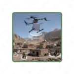
Operators deploy this Intelligent Airborne Electronic Reconnaissance System in complex electromagnetic environments for tactical reconnaissance. It executes missions involving radiation source localization and unidentified threat detection. Military and security forces use it for battlefield electromagnetic spectrum visualization. The system provides high-precision, three-dimensional direction finding for threat tracing. Its airborne perspective enables the localization of ground-based jammers and pilot positions. This capability is critical for securing borders, critical infrastructure, and active conflict zones.
For operators requiring top-tier airborne electronic support measures, Tactical Supply Pakistan delivers this cutting-edge platform. Our procurement ensures access to validated, frontline counter-unmanned aerial system technology for national security applications.
What is the system’s operational hover time?
It provides over 30 minutes of hover time with the radio detection suite active.
- Fast Shipping: We partner with reliable delivery services to make sure your order gets to you quickly. We work hard to ensure every package arrives safely and on time.
- Quick Processing: Your order is processed and prepared for shipping within 24 to 48 hours. This allows us to send it out to you as fast as possible after your payment is confirmed.
- Tracking: Once your order is on its way, we will provide you with a tracking number. You can use this number to easily follow your package's journey and know exactly when it will arrive.
- Nationwide Delivery: We offer delivery to all locations across Pakistan, including major cities and remote areas. No matter where you are, we can get your order to you.
At Tactical Supply Pakistan, our relationship with you doesn't end after a sale. We are dedicated to making the long-term performance and reliability of our high-quality tactical and supplied equipment. Our commitment is to provide you with seamless support and peace of mind.
- Free Installation: We'll set up your new equipment for you, so it's ready to go. You can focus on your work while our engineers handle as per the guidelines for manufacturer.
- Maintenance: We offer quick replacements where necessary, to keep your gear in top condition. Our team will make sure your equipment is always ready when you need it.
- Customer Support: We're always here to help. Our support team is available to answer your questions and assist you long after you've made a purchase.
- Planned Preventative Maintenance: Our service includes preventative maintenance to keep your equipment in peak condition and prevent future issues.
HAVE QUESTIONS?
Fill out the form, and our team will respond promptly to assist with your product inquiries or order support.


