Intelligent 3D Radio Direction-Finding System is a fixed-site, high-precision system for wide-area 3D RF surveillance and drone threat detection.
Key Features:
✔️ Full frequency coverage: 0.4–6 GHz with customizable detection ranges
✔️ Hemispherical detection up to 10 km, angle accuracy 1.5° RMS
✔️ Supports full polarization for stable signal reception
✔️ Tracks 30+ simultaneous targets with rapid detection cycles
✔️ RF signature recognition with Drone ID/Remote ID decoding (2.4/5.8 GHz)
✔️ Protocol analysis refresh rate: <5 s for Remote ID, ≤1 s per tracking cycle
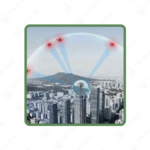
✔️ Field of view: 360° azimuth × 90° elevation for complete coverage
✔️ Persistent low-altitude awareness for airports, borders, and critical sites
✔️ AI-driven model ensures stable detection in dense electromagnetic environments
✔️ Provides 3D azimuth and elevation data to cue radar and optical systems
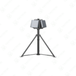
The Skyfend Tracer Matrix (STF200) is a fixed-site Intelligent 3D Radio Direction-Finding System. It operates across the full 0.4 to 6 GHz frequency band with customizable detection ranges. The unit offers a hemispherical detection coverage with a maximum range of 10 kilometers for targets like the DJI Mavic 3. Its angle accuracy is 1.5 degrees root mean square at higher frequencies. The system supports full polarization adaptability for stable signal reception. It can track over thirty simultaneous targets with a rapid detection cycle.
This system integrates RF signature recognition and protocol decoding capabilities. The protocol decoding function operates on the 2.4 GHz and 5.8 GHz bands. It decodes Drone ID and Remote ID broadcasts with an effective range of three kilometers. The data update rate for scanning Remote ID signals is under five seconds. For tracking, the update rate is one second or less per cycle. The effective field of view for protocol analysis is 360 degrees in azimuth and 90 degrees in elevation.
This Intelligent 3D Radio Direction-Finding System is deployed for permanent, wide-area radio frequency surveillance. It provides the foundational layer for integrated air defense at critical fixed sites. Security forces install it at borders, airports, and energy facilities for persistent low-altitude awareness. The system’s 3D direction finding supplies precise azimuth and elevation data to cue radar and optical systems. This enables layered defense architectures to engage unidentified drone threats efficiently. Its AI-driven model maintains detection stability in dense, complex electromagnetic environments.
Sourcing advanced spectral intelligence systems requires a trusted partner. Tactical Supply Pakistan provides verified access to this next-generation detection technology for strategic site protection.
What is the primary advantage of 3D over 2D direction finding?
It provides both azimuth and elevation data, enabling precise vertical localization of threats for accurate countermeasure cueing
At Tactical Supply Pakistan, our relationship with you doesn't end after a sale. We are dedicated to making the long-term performance and reliability of our high-quality tactical and supplied equipment. Our commitment is to provide you with seamless support and peace of mind.
Fill out the form, and our team will respond promptly to assist with your product inquiries or order support.
WhatsApp us