

NDVI Multispectral Camera for Drone
High-precision six-band multispectral imaging system engineered for crop health analysis, vegetation monitoring, and advanced environmental assessment.
Key Features:
✔️ Six-band imaging (Blue, Green, Red, Red-Edge 1 & 2, NIR) for NDVI mapping
✔️ 1.2MP global-shutter CMOS for blur-free high-speed surveys
✔️ 12-bit radiometric depth for accurate reflectance data
✔️ Large 3.75 µm pixels for stronger light sensitivity
✔️ DJI X-Port gimbal mounting with wide pan/tilt range
✔️ Automatic real-time radiometric calibration
✔️ Onboard reflectance processing to reduce post-work
✔️ 30 MB/s capture rate with 1-second intervals
✔️ Multiple trigger modes for mapping workflows
✔️ 64–128 GB storage for full survey missions
NDVI Multispectral Camera for Drone
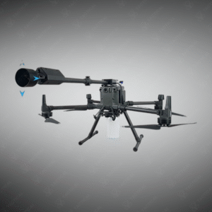
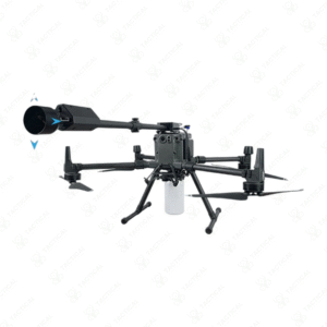
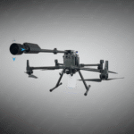
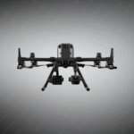
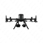
The NDVI Multispectral Camera for Drone measures 129 by 157 by 148 millimeters and weighs 655 grams in aluminum alloy construction. A 1.2-megapixel 1/3-inch CMOS sensor captures six distinct spectral bands spanning blue, green, red, red-edge 1, red-edge 2, and near-infrared wavelengths. Twelve-bit digital quantization depth records 4,096 intensity levels per pixel, enabling detailed capture across high-contrast agricultural scenes. A large 3.75-micrometer pixel size maximizes photon collection during rapid aerial survey missions. Global shutter architecture eliminates motion artifacts during high-speed platform movement across crop canopies.
DJI X-Port gimbal integration provides plug-and-play installation with pan-and-tilt articulation spanning plus-minus 320 degrees horizontal and minus 120 to plus 30 degrees vertical. Pan-tilt control executes 90-degree movements per second for dynamic nadir repositioning. Real-time radiometric calibration corrects ambient light radiation automatically during flight operations. Onboard synchrotron radiation calibration computes spectral reflectance values directly without post-flight processing. Data recording speed reaches 30 megabytes-per-second with 1-second capture intervals. Selectable trigger modes support overlap-rate and timing-controlled image sequences. Sixty-four to 128-gigabyte removable storage accommodates full-mission datasets.
Government agriculture extension services deploy the NDVI Multispectral Camera for Drone to assess crop health, detect disease progression, and optimize irrigation scheduling across district agricultural zones. Commercial precision farming operators generate normalized difference vegetation index maps guiding variable-rate fertilizer application. Forestry agencies monitor stand density, carbon sequestration rates, and disturbance recovery across timberland holdings. Water resource managers evaluate riparian vegetation health and detect invasive plant encroachment. Environmental research institutions track ecosystem phenology and climate-change responses across protected areas.
Tactical Supply Pakistan supplies this scientific-grade spectral imaging platform to agricultural agencies and commercial operators requiring accurate multispectral crop monitoring and precision resource management capabilities.
How does six-channel spectral capture improve crop health assessment compared to four-channel systems?
Red-edge and dual near-infrared bands detect early stress indicators invisible to standard RGB or four-channel sensors. Additional spectral data doubles analytical capability for disease identification and nutrient deficiency detection.
- Fast Shipping: We partner with reliable delivery services to make sure your order gets to you quickly. We work hard to ensure every package arrives safely and on time.
- Quick Processing: Your order is processed and prepared for shipping within 24 to 48 hours. This allows us to send it out to you as fast as possible after your payment is confirmed.
- Tracking: Once your order is on its way, we will provide you with a tracking number. You can use this number to easily follow your package's journey and know exactly when it will arrive.
- Nationwide Delivery: We offer delivery to all locations across Pakistan, including major cities and remote areas. No matter where you are, we can get your order to you.
At Tactical Supply Pakistan, our relationship with you doesn't end after a sale. We are dedicated to making the long-term performance and reliability of our high-quality tactical and supplied equipment. Our commitment is to provide you with seamless support and peace of mind.
- Free Installation: We'll set up your new equipment for you, so it's ready to go. You can focus on your work while our engineers handle as per the guidelines for manufacturer.
- Maintenance: We offer quick replacements where necessary, to keep your gear in top condition. Our team will make sure your equipment is always ready when you need it.
- Customer Support: We're always here to help. Our support team is available to answer your questions and assist you long after you've made a purchase.
- Planned Preventative Maintenance: Our service includes preventative maintenance to keep your equipment in peak condition and prevent future issues.
HAVE QUESTIONS?
Fill out the form, and our team will respond promptly to assist with your product inquiries or order support.