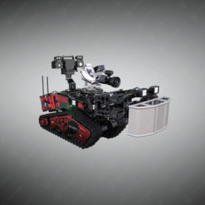
PREMIUM TACTICAL GEAR – SERVING CIVIL & DEFENSE SECTORS
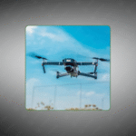
Collision‑tolerant quadcopter with LiDAR and 4K camera for industrial inspections in tight spaces.
Key Features:
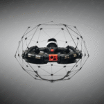
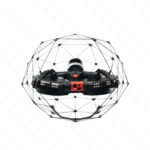
✔️ Collision‑resilient cage with reversible-thrust motors
✔️ LiDAR payload for millimeter-precision 3D mapping
✔️ 4K UHD video (3840×2160 @ 30 fps) + 12MP stills
✔️ Three vision cameras + ToF + IMU + magnetometer
✔️ Smart LED lighting up to 16,000 lumens
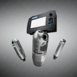
✔️ Onboard Nvidia Xavier NX computer for SLAM navigation
✔️ Flight time: ~9–12.5 min depending on payload
✔️ Ingress protection IP44 (base) / IP68 (LiDAR)
✔️ Lightweight, modular design (~1.9 kg)
✔️ Modular payloads for upgrades and sensor swaps
The ELIOS 3 Lidar Drone features a collision-tolerant cage structure measuring 48cm wide by 38cm high, protecting internal components during confined space operations. The quadcopter employs four brushless electric motors with reversible thrust capability, allowing stabilization after impact with walls or machinery. Construction materials include carbon fiber frame rails, Kevlar-reinforced protective spheres, magnesium alloy motor mounts, and aircraft-grade aluminum structural joints. The cage design enables the drone to maintain flight control while making contact with inspection surfaces, functioning similarly to a rolling ball inside industrial environments.
Onboard sensor suite includes an inertial measurement unit (IMU) for attitude control, a magnetometer for directional heading, and three computer vision cameras providing 360-degree obstacle detection. A LiDAR scanner generates three-dimensional point cloud maps of internal structures with millimeter accuracy, while time-of-flight (ToF) distance sensors measure proximity to surrounding surfaces. The primary camera captures 4K video at 3840×2160 resolution at 30 frames per second, or switches to Full HD 1920×1080 mode for extended flight duration.
Industrial facility managers deploy the ELIOS 3 Lidar Drone inside boilers, pressure vessels, and storage tanks to conduct visual inspections without scaffolding construction or confined space entry permits. Oil refinery operators fly it through distillation columns and heat exchangers, documenting corrosion patterns and weld integrity while process units remain operational. Mining companies use the system to survey underground shafts, creating accurate 3D models that identify structural weaknesses requiring maintenance attention.
Tactical Supply Pakistan supplies this inspection drone with pilot training programs and data processing software for converting LiDAR scans into engineering reports, reducing inspection downtime for critical infrastructure assets.
Can the drone operate in environments with metal grating that interferes with GPS signals?
Yes, the system uses visual odometry and LiDAR positioning for navigation in GPS-denied spaces like underground facilities or metal enclosures.
At Tactical Supply Pakistan, our relationship with you doesn't end after a sale. We are dedicated to making the long-term performance and reliability of our high-quality tactical and supplied equipment. Our commitment is to provide you with seamless support and peace of mind.
Fill out the form, and our team will respond promptly to assist with your product inquiries or order support.
WhatsApp us