


Drone RID Reader (FR1 / FR3) is a passive Remote ID decoding system designed for real-time identification and tracking of cooperative drones and operator data.
Key Features:
✔️ Decodes Remote ID broadcasts for drone serial, model, and flight data
✔️ Extracts pilot/controller location, altitude, speed, and course angle
✔️ Supports Bluetooth 4/5, WiFi Beacon, and NAN communication protocols
✔️ FR1 range: 1–2 km with up to 10 simultaneous drone detections
✔️ FR3 range: up to 3 km with high-frequency scanning (1–2 Hz)
✔️ Fast response time within 2–3 seconds (FR1)
✔️ IP65 (FR1) and IP66 (FR3) rated for all-weather operation
✔️ Compliant with GB 42590-2023, ASTM F3411, and ASD-STAN prEN 4709-002
✔️ Supports multi-unit networking for city-scale airspace monitoring
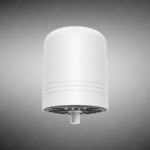
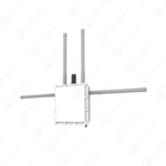
The Drone RID Reader is a Remote ID signal receiving and decoding system available in two configurations — FR1 and FR3. Both target cooperative drone monitoring by decoding RID broadcasts. They extract serial numbers, model identification, pilot coordinates, flight speed, velocity, altitude, and course angle. The FR1 measures 385×307×204mm and weighs approximately 13kg with IP65 protection. It operates between -40°C and 70°C, covers a 1–2km radius, and detects up to 10 simultaneous targets within 2–3 seconds. Additionally, it supports Bluetooth 4/5, WiFi Beacon, and NAN protocols, meeting GB 42590-2023, ASTM F3411, and ASD-STAN prEN 4709-002 standards.
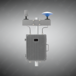
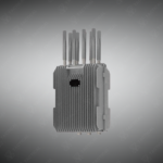
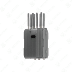
The FR3, however, is a lighter tower-mountable variant. It weighs approximately 2.5kg and measures 217×217×68mm with IP66 protection. It works at 2.4GHz and 5.8GHz frequencies, scanning 1–2 times per second and covering up to 3km radius. Furthermore, it supports Bluetooth 4/5, Beacon 5, and WiFi BEACON WB1/NAN, meeting identical international standards. The FR3 installs on traffic poles, telecom masts, perimeter fences, and towers. As a result, it supports city-level low-altitude airspace governance through multi-device wide-area networking.
Airport authorities deploy the Drone RID Reader for continuous cooperative drone identification across flight path perimeters. They display real-time drone location and pilot coordinates on electronic maps. Meanwhile, railway and industrial compound security teams use networked FR3 units along infrastructure corridors for low-altitude airspace monitoring. Similarly, urban air traffic management agencies integrate both models into city-wide supervision networks. These networks track flight trajectories and operator positions simultaneously.
For airports, infrastructure operators, and urban airspace management agencies requiring standards-compliant RID monitoring, Tactical Supply Pakistan supplies both FR1 and FR3 configurations with consultation on mounting options, network deployment planning, and RID protocol compatibility for specific low-altitude governance requirements.
What is the difference between FR1 and FR3 deployment scenarios?
FR1 suits fixed ground-level installations at high-security sites requiring fast multi-target response and jammer linkage. FR3 suits distributed urban pole-mounting across wide city areas where lightweight installation flexibility and broader radius coverage take priority over response speed.
At Tactical Supply Pakistan, our relationship with you doesn't end after a sale. We are dedicated to making the long-term performance and reliability of our high-quality tactical and supplied equipment. Our commitment is to provide you with seamless support and peace of mind.
Fill out the form, and our team will respond promptly to assist with your product inquiries or order support.
WhatsApp us


