PREMIUM TACTICAL GEAR – SERVING CIVIL & DEFENSE SECTORS
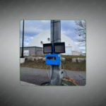
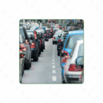
A rugged, multi‑radio detector that logs Bluetooth, Wi‑Fi, and BLE MAC addresses to measure journey times, delays, and traffic flow for vehicles and bicycles.
Key Features:
✔️ Detects Bluetooth, Wi‑Fi, and BLE MAC addresses
✔️ Measures journey times and delays in real time
✔️ Supports 7-day mobile autonomy
✔️ Classifies traffic into 3 vehicle categories
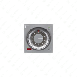
✔️ LED display shows live device status
✔️ Rugged IP67 enclosure for all-weather use
✔️ Connectivity via 4G/LTE modem, Ethernet, and MQTT
✔️ Secure transmission with SSL/TLS 1.2/1.3 encryption
✔️ 128 GB micro‑SD storage for local logging
✔️ API REST interface supporting JSON, XML, DATEX II
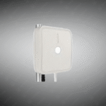
The BlueScan detects Bluetooth, WiFi, and BLE MAC addresses recording journey and delay times for personal transport and cycling. Dimensions measure 276×272×96.5mm weighing 2 kilograms. An ARM 9 CPU operates Linux-based firmware with 128GB micro-SD storage. Power consumption averages 3.8 watts with modem. Supply voltage ranges 12 to 48 VDC. Reception sensitivity reaches minus 102dB with directional antenna achieving 500-meter range. WiFi 6 and BLE 5.2 support omnidirectional detection spanning 100 meters. Operating temperature ranges minus 40 to plus 80 degrees Celsius. IP67 enclosure withstands NEMA TS2-2003 standards. Mobile deployment supports 7-day autonomy. Three vehicle categories enable analysis. CE/FCC/IC certification ensures compliance.
The system integrates optional 4G/LTE modems with Ethernet and MQTT connectivity. Advanced encryption and SSL/TLS 1.2/1.3 secure transmission. Directional and omni-antennas enable detection. Self-diagnosis monitors system health. The platform generates source/destination matrices and travel times automatically. LED display shows real-time status. API REST services deliver JSON, XML, and DATEX II formatted data. Multisource Control Center analyzes diverse data sources assessing quality in real-time. KPIs and asset management provide monitoring. Geographical information system displays real-time and historical data with forecasting.
Traffic planners deploy BlueScan for analyzing journey times and network weak points. Urban mobility specialists optimize traffic distribution and connections. Infrastructure planners substantiate project impact through travel-time analysis. Researchers measure segmental speeds. Public transit agencies track multimodal patterns. Environmental teams monitor congestion effects. City authorities support mobility behavior changes. Regional planners compare effectiveness across corridors.
Tactical Supply Pakistan manufactures advanced journey-time detection systems combining Bluetooth/WiFi sensing with AI analysis for comprehensive urban mobility intelligence and traffic optimization applications.
Can the BlueScan differentiate between pedestrians, cyclists, and vehicles?
Yes, three distinct vehicle classes enable multimodal classification. Speed measurement and directional antenna analysis distinguish movement patterns. The system separates cyclist/pedestrian detection from motorized vehicle classification through behavioral analysis algorithms.
At Tactical Supply Pakistan, our relationship with you doesn't end after a sale. We are dedicated to making the long-term performance and reliability of our high-quality tactical and supplied equipment. Our commitment is to provide you with seamless support and peace of mind.
Fill out the form, and our team will respond promptly to assist with your product inquiries or order support.
WhatsApp us