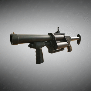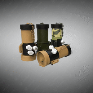


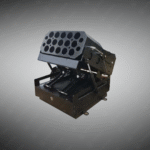
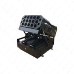
Vehicle Mount 15 Rounds Multiple Launcher
Vehicle-Mount 15-Rounds Multiple Launcher — vehicle-mounted, remote-operated multi-launcher with integrated optics and a quick-change 15-round magazine for area suppression, marking and less-lethal engagements.
Key Features:
✔️ Calibre & type: 37/38 mm dedicated or 40 mm option
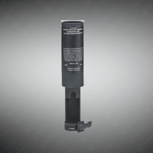
✔️ L 387 ±3 mm × H 370 ±3 mm × W 407 ±3 mm; barrel length 198 ±3 mm
✔️ Mass: Firing body ≈ 22.16 ±0.1 kg; mount/pan-tilt assembly ≈ 15.56 ±0.1 kg
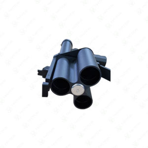
✔️ Magazine: Quick-change 15-round magazine; modular for fast reloads
✔️ Fire modes: Selectable single-shot, 5-shot bursts (×3 lines) or full 15-shot salvo
✔️ Optronics: Integrated day + night-vision camera with monitor feed for remote aiming
✔️ Traverse & elevation: Elevation ±45°; azimuth ≈ ±120° (custom angles available)
✔️ Remote display, shot-status LEDs, shooting-angle readout and battery level
✔️ Long-life internal rechargeable battery; vehicle cigar-jack charging
✔️ Mounting & protection: Robust bracket/mount system with outside protection cover
Vehicle Mount 15 Rounds Multiple Launcher
The Vehicle mount 15 rounds multiple launcher measures 387mm ± 3.0mm in overall length with height of 370mm ± 3.0mm. Width reaches 407mm ± 3.0mm for vehicle integration. Barrel length extends 198mm ± 3.0mm for ballistic consistency. Firing body weighs 22.16kg ± 0.1kg while the rotating mount weighs 15.56kg ± 0.1kg. Magazine capacity holds 15 rounds with quick-changeable cartridges. Caliber options span 37/38mm or 40mm variants with cross-compatibility.
The launcher rotates vertically up to 45 degrees and horizontally approximately 120 degrees. Day and night vision camera systems provide operator visibility in all lighting conditions. Fire modes allow single-shot discharge, five-shot consecutive patterns, or all fifteen rounds simultaneously. Remote control display shows real-time external images with barrel fire indication lights. Shooting angle display guides operator targeting precision. Long-lasting internal battery charges via vehicle cigar jack connection.
Law enforcement agencies deploy the Vehicle mount 15 rounds multiple launcher during large-scale crowd management operations. Perimeter security teams utilize the system for defensive coverage around high-value installations. Correctional facility response units position it for rapid multi-target engagement. Border patrol forces employ the system for area denial along restricted zones. Military training units incorporate the platform for tactical doctrine development.
Tactical Supply Pakistan delivers this advanced launcher system to security forces requiring force multiplication during critical incidents. The vehicle-mounted configuration extends operational effectiveness beyond portable platforms. Professional units depend on this equipment for coordinated response capability in complex scenarios.
How does night vision camera integration assist operators during low-light scenarios?
Thermal and image intensification cameras provide full situational awareness during darkness, allowing targeting without ambient light. Battery reserves ensure continuous operation across extended low-light operations.
- Fast Shipping: We partner with reliable delivery services to make sure your order gets to you quickly. We work hard to ensure every package arrives safely and on time.
- Quick Processing: Your order is processed and prepared for shipping within 24 to 48 hours. This allows us to send it out to you as fast as possible after your payment is confirmed.
- Tracking: Once your order is on its way, we will provide you with a tracking number. You can use this number to easily follow your package's journey and know exactly when it will arrive.
- Nationwide Delivery: We offer delivery to all locations across Pakistan, including major cities and remote areas. No matter where you are, we can get your order to you.
At Tactical Supply Pakistan, our relationship with you doesn't end after a sale. We are dedicated to making the long-term performance and reliability of our high-quality tactical and supplied equipment. Our commitment is to provide you with seamless support and peace of mind.
- Free Installation: We'll set up your new equipment for you, so it's ready to go. You can focus on your work while our engineers handle as per the guidelines for manufacturer.
- Maintenance: We offer quick replacements where necessary, to keep your gear in top condition. Our team will make sure your equipment is always ready when you need it.
- Customer Support: We're always here to help. Our support team is available to answer your questions and assist you long after you've made a purchase.
- Planned Preventative Maintenance: Our service includes preventative maintenance to keep your equipment in peak condition and prevent future issues.
HAVE QUESTIONS?
Fill out the form, and our team will respond promptly to assist with your product inquiries or order support.